


Agricultural Land Leveling Control System
The agricultural land leveling equipment system is built to level land accurately for farming and building work. It uses satellite signals and a smart computer to make the ground flat with high precision. The system is easy to operate with any standard tractor, works well on all types of land, and also saves time and hard work. It automatically moves the blade, shows live maps, and stays connected to strong satellite signals.
Technical Specifications
On-board Computer (10-inch Car Computer):
- Dimensions: 280 × 180 × 50 mm
- System: Android 9
- Processor (SoC): Qualcomm Octa-core (8953)
- Memory: 2 GB RAM + 16 GB Storage
- Display: 10.1 inches, 1024 × 600 resolution
- Protection Level: IP65
More Technical Specifications
On-board Computer (10-inch Car Computer):
- WiFi: IEEE 802.11 b/g/n
- 4G Network Support: LTE-FDD (B1 / B3 / B5 / B8), LTE-TDD (B34 / B38 / B39 / B40 / B41)
- Bluetooth: SPP, BLE
- SIM Card Slot: Supported
- Speaker: Supported
- Satellite Dish Support: 1-2 channels
- Data Interface: 1 channel supported
Land Leveling System Features:
- Leveling Accuracy: ±2 cm
- Working Modes: Flat Mode, Bevel Mode, Double Bevel Mode
- Display Interface: Real-time digital elevation map
- Core Functions:
- Automatic blade control
- Automatic lifting and lowering
- Height difference guidance
- Digital visual monitoring
RTK Specifications:
- Positioning System: Full system, full frequency, single and dual antenna supported
- Satellite Frequency Bands:
- BDS: B1I, B2I, B3I, BI1C, B2a, B2b
- GPS: L1 C/A, L2P(Y), L2C, L5
- Galileo: E1, E5a, E5b
- GLONASS: L1, L2
- QZSS: L1, L2, L5
- RTK Accuracy:
- Plane: 0.8 cm + 1 ppm
- Elevation: 1.5 cm + 1 ppm
- Time Accuracy: 10 ns
- Directional Accuracy: 0.2° per 1 m baseline
- Speed Accuracy: 0.03 m/s
- RTK Initialization Time: Less than 5 seconds (typical)
- Operating Temperature: -40°C to +85°C
- Operating Voltage: 9 - 16 VDC
- Working Current: Maximum 2.5 A


Product Features
High-Precision RTK Satellite System
The land leveling equipment system uses advanced RTK satellite technology to give you incredibly accurate measurements. It's compatible with all main satellite signals, such as BDS, GPS, Galileo, GLONASS, and QZSS. On a flat surface, it can be correct to 0.8 cm, and in terms of height, it can be accurate to 1.5 cm. It pairs in under 5 seconds and lets you get to work quickly.
Real-Time Performance Data
The land leveling tools present you with real-time data that will enable you to move the blade accurately and smoothly. It has an accuracy of 0.2 degrees in direction per meter, 0.03 meters per second in speed, and 10 nanoseconds in time. It helps the system adapt quickly during leveling, even on large surfaces, so your work stays stable.
Multifunctional 10-Inch Android Computer
The 10-inch Android computer can be used on the vehicle/machine. It's powered by Android 9 with a speedy Qualcomm 8-core processor. It has 2GB of memory and 16GB of storage, so it operates smoothly for most uses. The screen is clear and bright with a 1024x600 resolution. It's also protected from water and dust (IP65 rated), so you can safely use it outside in different weather conditions.
Easy Connection and Device Support
The onboard computer is compatible with other devices and networks. It works with WiFi (IEEE802.11b/g/n), 4G LTE (all common bands), and Bluetooth (SPP, BLE). You can also use a SIM card, and it has one satellite dish and one data transmission channel. These features help the system stay connected and send or receive live updates during work.

3 Working Modes
The land leveler machine has three easy-to-use working modes: Current Plane Height, Terrain Measurement, and Double Slope Mode.
In Current Plane Height mode, you can set a target ground level for the land. The machine then cuts down high spots and fills in low spots to match the set level. This helps make the land flat and even.
In Terrain Measurement mode, the tractor drives over the land and collects data about the surface. The system uses this data to find the best level height and then starts leveling the land automatically.
Double Slope Mode is useful for land that needs to be finished with a slope. You can mark three points (A, B, and C) on the land to form a right triangle. The system calculates the slope between A-B and B-C. You can also set the slope angles yourself if you want. This is helpful when different parts of the land need different slopes.
Smart Blade Control
The Precision Land Leveling system adjusts the blade height for you while you work. It also displays a live map on your screen that indicates whether the ground is higher or lower and by how much. This makes the work simpler because you don't have to guess it or manually measure it out. It helps you work faster, reduce mistakes, and level the land better.
Compatibility
- Supports GPS, BDS (BeiDou), GLONASS, Galileo, and QZSS satellite constellations.
- Operates on multiple frequencies, including:
- BDS: B1I, B2I, B3I, BI1C, B2a, B2b
- GPS: L1 C/A, L2P(Y), L2C, L5
- Galileo: E1, E5a, E5b
- GLONASS: L1, L2
- QZSS: L1, L2, L5
- Supports 4G (LTE-FDD & LTE-TDD), WiFi (IEEE802.11b/g/n), and Bluetooth (SPP, BLE) for full communication.
- SIM card is supported for mobile data communication.
Use Cases
- Agricultural land leveling and field levelling
- Construction site ground preparation
- Road and foundation grading
- Irrigation planning and water management
- Large-scale land development
- Land surveying with high accuracy
- Smart farming automation
- Public infrastructure leveling (canals, parks, schools)
- Soil leveling for greenhouse setups
- Terrain correction for landscaping projects


Agricultural Land Leveling Control System Pros & Cons
Product Pros
- The system keeps leveling accuracy within ±2cm. This removes human error and ensures better results for things like even water flow in farming and solid foundations for building.
- It can handle different land types like farms, parking lots, sports fields, and sloped roads. With smart blade control, it adjusts to the land automatically. This makes the work over 60% faster, cuts the work time by 30-50%, and lowers labor costs by up to 80%.
- It creates live color maps that show land height differences and job progress, so there’s no need to guess anymore.
- You can switch between work modes with one click - no special skills needed.
- Setup takes just 2 hours, and you can learn to use it in 1 day. It works with more than 90% of tractors without extra changes.
- The strong design lets it work in extreme weather from -40℃ to 85℃. A 24/7 remote help system can find and fix problems in 30 minutes, so there’s less downtime and fewer delays.
Customer Reviews
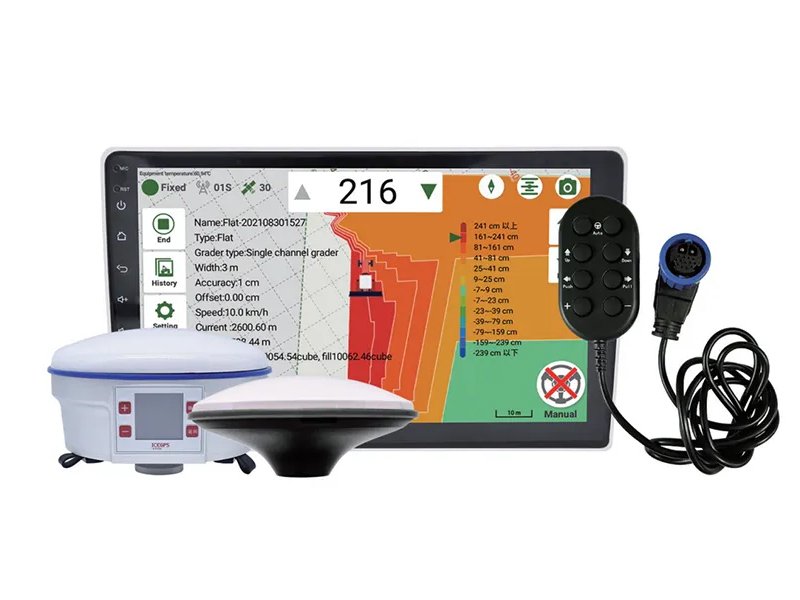
The Cube RTK GNSS GPS is a multifunctional surveying device that delivers centimeter-level accuracy for land mapping, construction, and research. With support for GPS, GLONASS, Galileo, and BeiDou satellites, it ensures reliability in all terrains. Featuring IMU-based tilt compensation, 4G/Wi-Fi/Bluetooth connectivity, and 12-hour battery life, it is a compact yet powerful solution for surveyors and engineers.

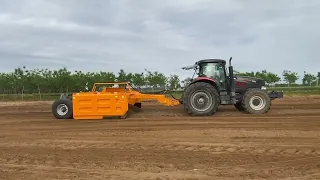
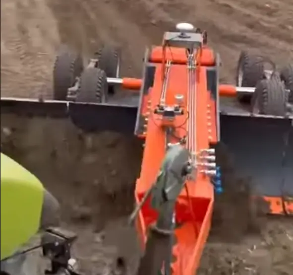
Accurate land leveling is critical for maximizing crop yield and efficient water use. Using RTK GNSS technology, farmers can achieve perfectly leveled fields, reducing irrigation costs and improving soil health. Our land leveling solutions ensure uniform water distribution, increased productivity, and sustainable farming practices.

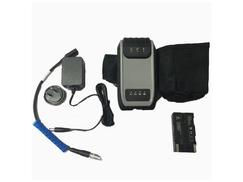
The Handheld RTK unit combines mobility with precision. Designed for fieldwork, it allows surveyors, engineers, and farmers to collect accurate coordinates without bulky setups. Its easy-to-use interface and real-time correction support (NTRIP) make it ideal for on-the-go tasks like boundary marking, site inspections, and agricultural planning.

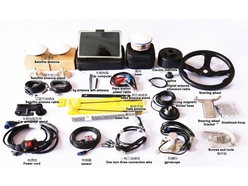
The Auto Steering System (Autopilot) helps farmers achieve straight, repeatable rows with minimal overlap. Powered by RTK precision, it guides tractors and machinery automatically, saving time and fuel. This technology reduces operator fatigue, improves efficiency, and ensures better results for planting, spraying, and harvesting operations.

Frequently Asked Question
Accordion Title One
Anim pariatur cliche reprehenderit, enim eiusmod high life accusamus terry richardson ad squid. 3 wolf moon officia aute, non cupidatat skateboard dolor brunch. Food truck quinoa nesciunt laborum eiusmod. Brunch 3 wolf moon tempor, sunt aliqua put a bird on it squid single-origin coffee nulla assumenda shoreditch et. Nihil anim keffiyeh helvetica, craft beer labore wes anderson cred nesciunt sapiente ea proident. Ad vegan excepteur butcher vice lomo. Leggings occaecat craft beer farm-to-table, raw denim aesthetic synth nesciunt you probably have not heard of them accusamus labore sustainable VHS.